Special Issue

Good Growth in the Cambridge-Oxford Arc

Good Growth in the Cambridge-Oxford Arc
#tcl_block--article-text

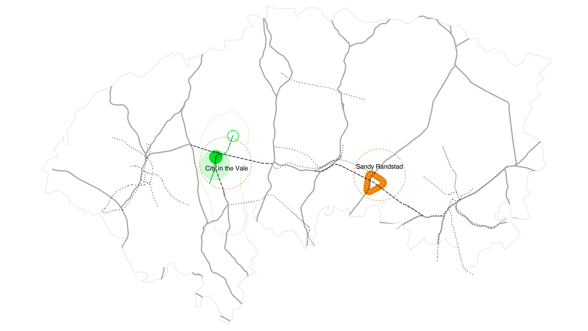
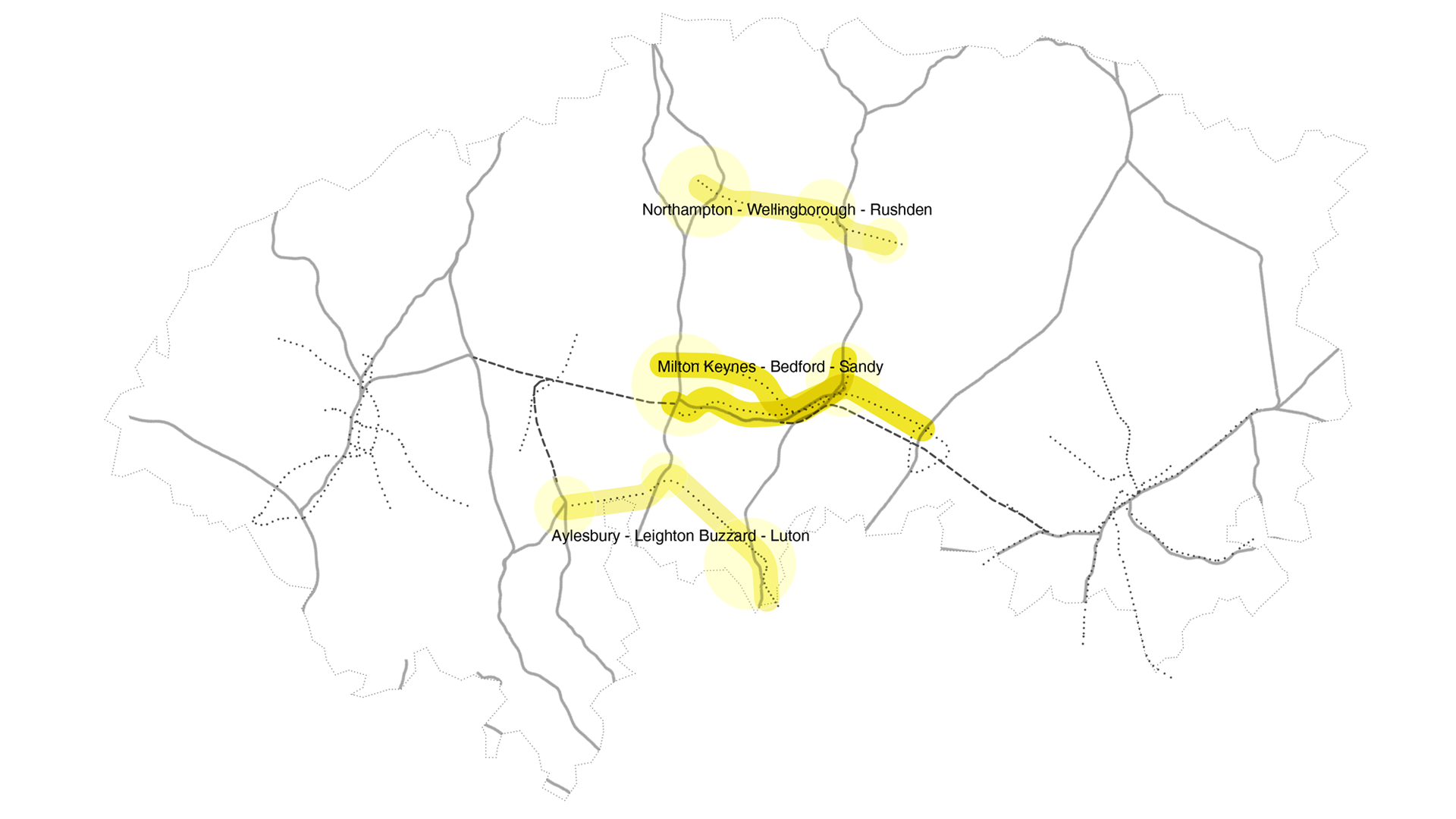
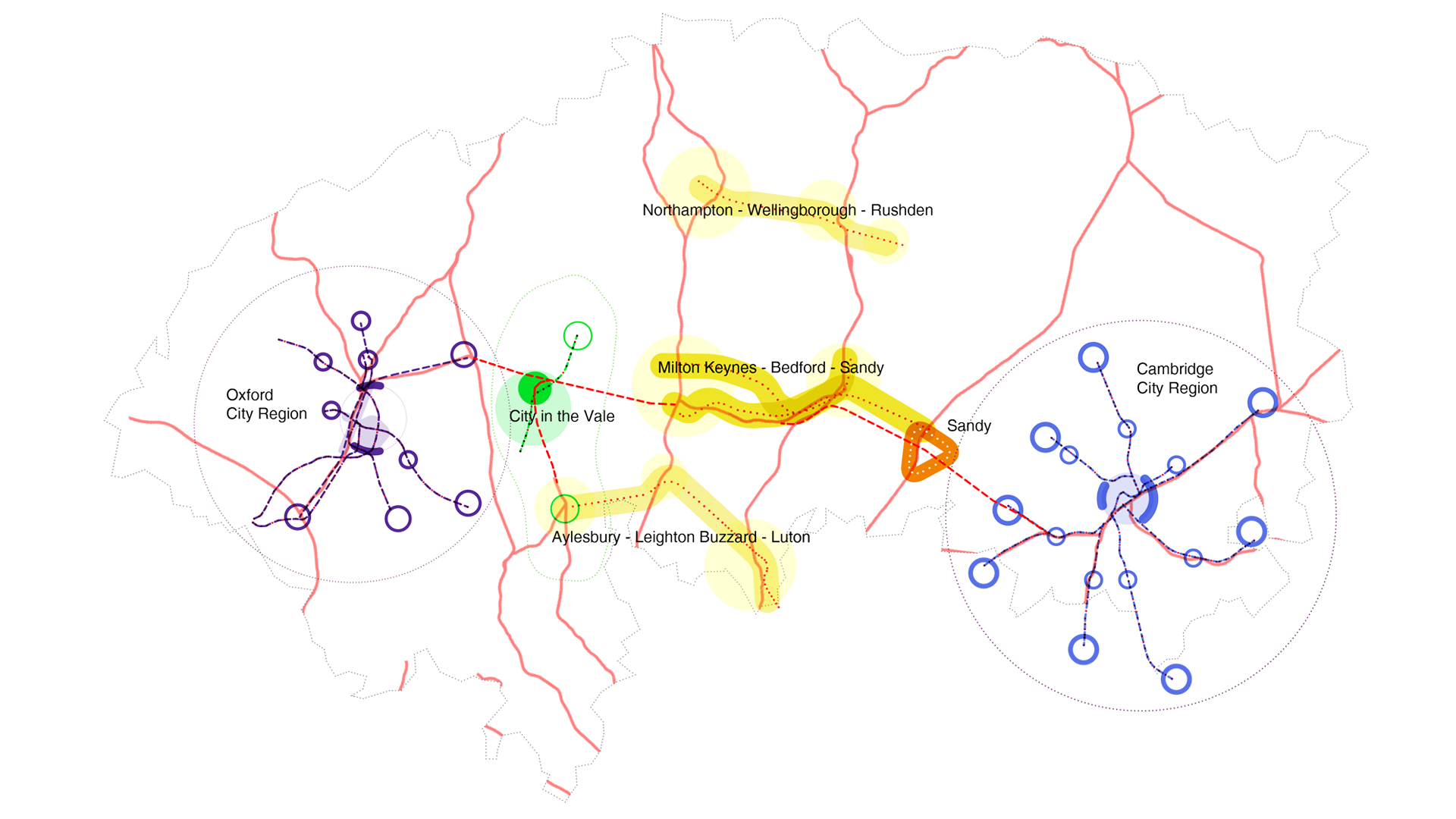
Horizontal integration of urban tissue beyond the immediate urban cores can provide a strategy to relief the pressure on congested transport infrastructures and overheated metropolitan centres. It can create independent growth opportunities for networks of small and medium-sized cities and regions. 5th Studio’s work – comprehensive and with great attention to local originality – offers a framework for the region’s development and manages to describe a path to sustainable growth. Even more, the study displays a set of coordinated development options for infrastructure and settlement, that can be used as a blueprint for similar considerations in comparable regions of Europe.

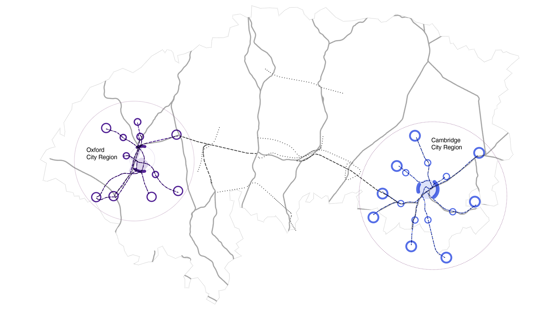
The Oxford-Milton Keynes-Cambridge Arc is a 100-mile line of towns and cities experiencing rapid growth beyond London’s green belt. The Arc is bookended by two world-class universities and also contains a significant ecology of educational institutions and leading science and innovation research and development.

#tcl_block--article-picture-text
Fast Growth Cities beyond London’s green belt
Credit: 5th Studio
#tcl_block--article-text

The environment and productivity of the urban economies in the Arc are threatened by a range of factors: road congestion caused by inward commuting, significant financial inequality, inadequate affordable housing supply and a shortage of key skills. The urban think-tank Centre for Cities identifies Cambridge as the UK’s fastest-growing city – highly educated and the most successful in bringing forward new patents – but also as Britain’s most economically unequal place.

5th Studio were commissioned by the UK’s National Infrastructure Commission to explore how a million additional homes might be accommodated in the territory by 2050 – roughly matching the rate of population growth over the last century. We were asked how this growth might be integrated with supporting infrastructures and to consider environmental sustainability, quality of life and protection of the area’s environment and cultural assets.

Enriching an extensive urban carpet of a challenged territory

We commenced our work by investigating what was happening in the territory in terms of land use. Although Milton Keynes was the culmination of an influential series of British New Towns, from Ebenezer Howard’s Garden City though the post-war reconstruction programme by planners like Patrick Abercrombie, regional planning has, with the odd exception, been politically unpopular in the UK since the 1980s. This absence of the guiding hand of the state is evident: delivery of housing has been delegated to the market, which left to its own devices has failed to deliver adequate quantity or quality, while making poor use of finite resources. With the obvious locations for human settlement all largely occupied, “housebuilders” – the virtual monopoly on housing delivery in the UK – have focussed on the remaining low-hanging fruit, without the ability to bring critical mass and enabling infrastructure to irrigate new places with potential.

#tcl_block--article-picture-text
Mapping of the existing fragmented economic clusters within the Arc – how could these develop and be augmented by a more functional physical relationship between places?
Credit: 5th Studio
#tcl_block--article-text

The arc’s chronic undersupply of homes is made worse by poor east-west transport connectivity, eclipsed by the strong radial transport network emanating from London. Currently experienced, existing links between these places are weak: the arc is not a functional one in terms of physical or economic interrelationships. Plans are advanced to restore a rail link across the Arc, removed in the 1960s, together with a more controversial expressway. An important layer of metropolitan-scale transport is lacking, with light rail and final-mile networks required in Oxford and Cambridge at the very least.

Obscured by the awkwardness of transitioning across the Arc are strong latent continuities, and not only in terms of economic orientation and growth: to a geologist this landscape really has a unity, united by a common clay watershed which has brought similar influences to the settlements within it, each shaped and defined by the major rivers flowing through the territory.

#tcl_block--article-picture-text
The territory has a singular geological identity as a clay watershed, where towns and cities are shaped by the great waterways. A coherent plan could allow this unity to be more evident through a new public landscape, while also reinforcing a set of multivalent places of quite specific character.
Credit: 5th Studio
#tcl_block--article-text

The study implicitly explores the potential that could emerge from making the corridor more functional, linking existing economic clusters in a way that creates more than the sum of the parts. A more connected corridor would establish a stronger sense of unity, but it is important that this is achieved in a way that reinforces the diversity and different characters of the places along the way.

#tcl_block--article-gallery
Serie 1
The strategy for the spatial distribution of growth differs according to location within the corridor. The diagram above summarises five sub-regional zones (from left to right): Oxford City Region, Calvert, Three East-West Stitches creating the Eight Town Figure-of-Eight, Sandy and the Cambridge City Region. Credit: 5th Studio
Serie 2
The strategy for the spatial distribution of growth differs according to location within the corridor. The diagram above summarises five sub-regional zones (from left to right): Oxford City Region, Calvert, Three East-West Stitches creating the Eight Town Figure-of-Eight, Sandy and the Cambridge City Region. Credit: 5th Studio
Serie 3
The strategy for the spatial distribution of growth differs according to location within the corridor. The diagram above summarises five sub-regional zones (from left to right): Oxford City Region, Calvert, Three East-West Stitches creating the Eight Town Figure-of-Eight, Sandy and the Cambridge City Region. Credit: 5th Studio
Serie 4
The strategy for the spatial distribution of growth differs according to location within the corridor. The diagram above summarises five sub-regional zones (from left to right): Oxford City Region, Calvert, Three East-West Stitches creating the Eight Town Figure-of-Eight, Sandy and the Cambridge City Region. Credit: 5th Studio
#tcl_block--article-text

Our response avoids identifying a “silver bullet”, but rather illustrates nine approaches which range from retrofitting existing places (for example, Bedford, a town with good infrastructure and underused land in the centre) to the creation of wholly new autonomous settlements. Each approach is illustrated at an appropriate locale on the ground and is keyed to a reference project illustrating where this approach has been done well.

#tcl_block--article-picture-text
Nine approaches ranging from retrofitting existing places to the creation of wholly new autonomous settlements were sketched out and keyed to best-practices
Credit: 5th Studio
#tcl_block--article-picture-text
The nine typologies for growth, tested on the ground in appropriate locations.
Credit: 5th Studio
#tcl_block--article-picture-text
The typology for suburban intensification is tested in Milton Keynes, where low density land is connected with a ‘metro’ transit spine running between the central station and Cranfield University, currently in an isolated location to the east of the new town.
Credit: 5th Studio
#tcl_block--article-text

A path to interweave growth and sustainability in sight?

Since the study’s publication, the UK has been distracted by political upheaval around Brexit, and yet a more interventionist approach seems now more urgent. The challenges are political: how to get more planned, as opposed to ad-hoc, growth, in a popularly acceptable narrative? How might the case for planned growth be reconciled with a growing desire for more sustainable development?

Following the elections in December, the new government has undertaken to develop a long-term Spatial Framework to support strategic planning in the Arc and to examine and develop the case for up to four new Development Corporations: could this be the start of a more energetic state, shaping change in the Arc?

When questioned, existing residents in the Arc are likely to talk about their feeling of encroachment: the sense that open land is being consumed by building development. While the data suggests that the percentage of land built on in the region is around 23 per cent (higher than the UK average of 5.9 per cent) the experience is further accentuated by sprawl and the low-density use of the available land resource, reinforcing the impression of loss.

#tcl_block--article-picture-text
Analysis of growth in the Arc from 1900 to 2015, illustrating increasingly low density use of land.
Credit: 5th Studio
#tcl_block--article-text

In need of a comprehensive vision

The Arc already coincides with the most water-stressed area of the UK and the growth illustrated in the study would create severe additional strains on a landscape which is increasingly prone to drought as the climate changes, putting pressure on its rivers and aquifers, on the availability of water for agriculture and industry, as well as domestic use.

Ironically, for one of the most densely populated parts of the country, the east of England also has some of the most limited access to large-scale high-quality open space in the country, with one of the smallest areas of National Park/Areas of Natural Beauty for any region.

Finally, all the cities in the Arc have declared a climate emergency and, together with key institutions such as the University of Cambridge, have made commitments to reducing their carbon footprint from current levels.

Taken together these three factors – water stress, access to nature and biodiversity, and carbon reduction – challenge the proposition of sustainable growth. The growth study, therefore, needs a complementary vision to underpin its findings: the potential of a new public landscape and waterscape conceived at an equivalent hundred-mile scale, that re-sets the relationship between the built and natural environment and allows a net-zero carbon approach.

#tcl_block--article-picture-text
There are fewer places in the Arc to locate a settlement at scale, but Calvert – at the intersection of the restored Oxford-Cambridge rail line and HS2, the UK’s first domestic high speed rail service becomes a highly connected location. A new city is proposed here, conceived of as a ‘city in a garden’: a dense and multivalent development surrounded by productive parkland.
Credit: 5th Studio
#tcl_block--article-text

The opportunity now exists to move from a market-determined model, making poor use of scarce resources, to a more collaborative relationship between bottom-up and top-down. A positive response would be the establishment of a mission-orientated approach that welds leadership on the ground –connected with the communities they serve and given greater devolved resources – combined with the ability of the state to plan, assemble land at scale and to invest in infrastructure.

#tcl_block--article-additional-info
Tom Holbrook

Tom Holbrook, 5th Studio Architecture and Urbanism

Tom Holbrook is founding director of 5th Studio Architecture and Urbanism, London and Professor for Architecture and Urban Design at RMIT University, Melbourne. His spatial design approach works across the fields of architecture, urban design, infrastructure and landscape.


#tcl_block--article-additional-info

We are interested in your viewpoints:

Comment and discuss this article on our facebook page, or get in touch with the authors or the editors by e-mailing us magazine@urbanes.land.

#tcl_block--article-additional-info

Endnotes 

In 2016 the former Chancellor of the Exchequer, George Osborne, asked the UK’s National Infrastructure Commissionto“make recommendations to maximize the potential of the Cambridge – Milton Keynes – Oxford corridor as a single, knowledgeintensive cluster that competes on the global stage, whilst protecting the area’s high-qualityenvironment and securing the homes and jobs the area needs..” In support of this inquiry, 5th Studio were appointed by the National Infrastructure Commissionto“reach conclusions and make recommendations for the forms of housing development that best fit the needs of the corridor, meeting housing need and supporting jobs and growth.” 

The National Infrastructure Commissionis an independent body advising the UK government with impartial, expert advice on major long-terminfrastructure challenges. The Commission’s objectives are tosupport sustainable economic growth across all regions of the UK, improve competitiveness; andquality of life. 


Bibliography 

www.5thstudio.co.uk/projects/oxford-milton-keynes-cambridge-corridor/ 

www.nic.org.uk 

www.centreforcities.org 


A GIS-based Land-cover Atlas, produced by the University of Leicester, The Centre for Landscape and Climate Research and SpectoNatura and supported by Defra and the European Environment Agency under Grant Agreement 3541/B2012/R0-GIO/EEA.55055 with funding by the European Union. 

https://figshare.shef.ac.uk/articles/A_Land_Cover_Atlas_of_the_United_Kingdom_Maps_/5219956